Wednesday, June 3, 2015

Cycle path for Lexington overpass?

Wednesday night, Waterloo city staff presented their proposal for Lexington Road to the public. After three years of silence, we now get to see how we might bridge Waterloo's great cycling gulf.

The Basics 


The proposal is an interim plan. Staff are telling us what they can do now, instead of ten years from now.

As part of resurfacing Lexington Road, the city of Waterloo proposes to create a multi-use trail that turns into a 2-way cycle path over the highway 85 overpass. Because the overpass cannot be structurally modified, the idea is that this cycle path would take up a traffic lane and be protected from traffic by some form of barrier, possibly jersey barriers.

The proposed multi-use trail will connect Davenport to Holbeach Crescent. That will get people on bike across the expressway, and provide connection through the neighbourhood to the Forwell trails and the rest of the Waterloop.

Click to embiggify.


This part of the Lexington corridor would turn into 2 eastbound lanes, and 1 westbound lane. Travelling further west, it opens up to 2 lanes by the time you reach the Dearborn traffic lights at the bottom of the hill. Further west, there are not many changes.


Not to be forgotten are a couple of pedestrian refuges which will make crossing Lexington on foot safer, and catching GRT's route 31 bus on the other side of the street less of a terrifying adventure. (Seriously, I've watched the terrifying game of Frogger that these riders play.)

So, why this plan? What's going on?

The Background


Like I said, this is an interim plan. In ten to fifteen years, this road could be reconstructed. Before then, the city hopes to have acquired the land they need (especially around Weber) to create a permanent cycling solution while not constricting traffic. That's their goal.

The bridge has been, and continues to be the worst problem. Anything the city does to it has to be approved by the MTO. Structural changes are extremely unlikely. Even what's proposed here still needs their blessing. The good news is that the MTO is apparently much more willing to consider this kind of plan now than they were four years ago.

The last time this stretch of road came up, a proposal to reduce lanes to introduce on-street bike lanes further west was rejected and deferred by council. Possibly as a result of that, staff want to maintain 4 road lanes west of Dearborn leading up to Weber.

What staff have presented fits within their budget. This means they don't need extra money to do this. But is it enough?


The verdict


What this proposal does is add a vital, safe cycling link across the expressway to connect Eastbridge to the Waterloop. Filling that gap is critical. So that's very good.

It doesn't complete the Columbia/Lexington east-west corridor. That is a disappointment.

Despite that, I believe we must support this proposal. Here's why:

To "do this right" would require the city to fund a new multi-million dollar plan that will take years, maybe a decade. Recognizing that, City staff rescued the idea of an interim plan from the scrapheap.

They've come up with something that solves the issues that council raised with the previous proposal. They've done it cheaply, and they could have this in front of council for approval this fall, with potential construction in 2016. We need more of this imaginative problem solving. There are so many critical gaps and problem spots in Waterloo region's cycling network that need attention now. But there is only so much money to go around.

If you punish staff for coming up with pragmatic solutions that can be implemented quickly, we will only see improvements when roads come up for full reconstruction, which means our network will only get random improvements going in haphazardly over the coming decades without regard to need.

What this proposal does well is connect Eastbridge to the rest of Waterloo in a way that people of all ages can hop on a bike and use. That is the critical need. It also helps us build cycling numbers and that will in turn increase momentum for other incremental improvements.

And it is a template for future problem-solving. Not every improvement needs to be as polished and completely conceived as Uptown's streetscape. What we need are pilot programs. We need staff and councils willing to engage in low-cost risk taking. We need to fill the gaps in our cycling network now, whatever way we can.

That's why this proposal deserves a thumbs up. It's not the big win some people were hoping for, but it is definitely a win. And small wins over time add up to big gains.


Tuesday, June 2, 2015

Columbia/Lexington road improvements consultation Wednesday!

This is a big one! After a four year wait from the last attempt at addressing Waterloo's great cycling gulf, Lexington Road over the expressway is finally back on the table.


There is a public consultation for Columbia St. E and Lexington (from King to Davenport) Wednesday, June 3rd from 6:00pm to 8:00pm, at the Mennonite Brethren Church, 245 Lexington Road.


If you want to ride a bike in the city of Waterloo, please consider attending. If you can't, then make a point to provide feedback when the material from the consultation goes online.

Let's recap:

  • The city of Waterloo currently has no bike infrastructure that crosses the expressway. It is Waterloo's great cycling gulf.
    • Soon, there will be a multi-use trail underneath the expressway at King St. North, which will provide some access to the Conestoga mall area.
  • Lexington Road is the only crossing in Waterloo without on/off ramps.
  • Lexington Road is the only crossing in Waterloo that is a city street (not a regional road).
  • Lexington Road is the quietest, lowest-traffic crossing point in Waterloo. It also appears to be the busiest cycling crossing point of the expressway.
  • Lexington/Columbia is an as-yet incomplete planned east-west cycling corridor. This study area is the critical missing piece.

In 2011, the city consulted on potential improvements that included on-street bike lanes, and reducing Lexington to 3 lanes between Davenport and Marsland. Despite the fact that the road is overbuilt for the amount of traffic it sees, the proposal drew concerns and unanswered questions from council at the time and the project was deferred in 2012.

Since then, Davenport's road diet has been completed, and so have the bike lanes along Lexington east of Davenport (with some multi-use trail action coming as well.) Hillside Park and Forwell Creek Park are now part of the "Waterloop" and crossing and connectivity points are being improved.

What will staff bring forward at the new consultation? I'm not sure, but it will hopefully provide a good cycling connection to the Waterloop, and reduce the speeding problem along Lexington. Could it even fill the very challenging King-Weber gap? We'll see.

It will need public support! I hope to see you there.

Thursday, May 28, 2015

Uptown Streetscape is a thing!

On Monday, I had the great pleasure of speaking to Waterloo City Council on behalf of the region's Active Transportation Advisory Committee. In our last meeting, the committee endorsed the plan presented by the project consultants and city staff to revamp Uptown Waterloo's streetscape with wider sidewalks and protected bike lanes.

I also had the pleasure of watching that plan passed unanimously.

The plan was the product of multiple consultations and strong public feedback, which I wrote about previously here and here. I also helped get the word out about protected bike lanes on twitter, on CBC radio (sadly the clip is no longer available), and in blogs. Together with the efforts of a number of passionate individuals, including the inimitable Graham Roe (whose petition garnered a thousand signatures) and tireless Mike Boos (who designed the amazing infographic) we got Waterloo informed, and engaged.

The people spoke, and the project team listened. The BIA got on board, and so did the politicians. What a journey! Considering that in 2010 I heard from one streetscape committee member about the very passionate arguments around the table about removing any traffic lanes at all, this points to a real evolution in thinking by many members of our community.

There are still a few rough edges. While Waterloo has a plan to replace lost parking (the streetscape plan will cost 22 parking spaces, but the LRT construction will affect considerably more), this plan still needs to become a reality and businesses will need to see their customers continue to reach them, whether it's by foot, bike, or car.

There is also the question of intersection design. Protected bike lanes will interact with these intersections similarly to on-street bike lanes, in that they'll be alongside traffic lanes and clearly visible at intersection approaches.

But there are other approaches we could take, including this adaptation of Dutch intersection design for Boston's Commonwealth Avenue.


Or even better, we could take a step further and implement a "protected intersection".


Just some thoughts on how to polish this plan to perfection.

Wednesday, May 27, 2015

The art and science of transit stop placement

Man, it's been a while since my last post! I've been busy with the Active Transportation Advisory Committee, still working a little with TriTAG, but mostly taking care of real life. But the march of progress brings new lessons and observations. I have a few things to post about now, but I'll start with what is freshest on my mind.

And that is: we're seeing new transit routes being created, and we're making some mistakes with transit stop spacing and placement. But there's confusion about why they're mistakes. Mistakes are being made because we're treating the entire region with the same standard, without considering that parts of our region, the cores, have more potential riders and potential destinations.  

Our system will benefit more from more closely spaced stops at strategic locations within these dense urban areas than from assuming one central stop can serve an entire core, or that one standard can serve an entire region.

Some background:


The new 204, and Queen St.


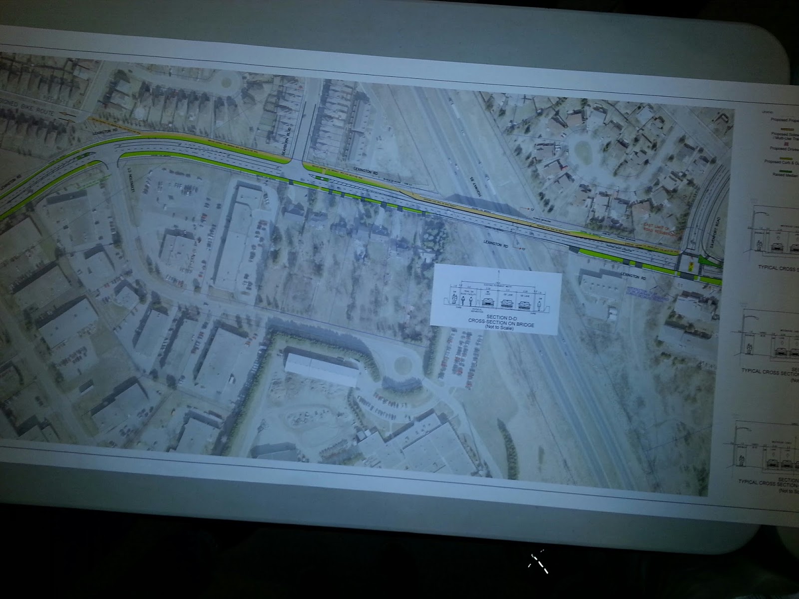
Regional Council's Planning & Works committee heard from a few delegations on Tuesday about the upcoming GRT improvements. There are concerns about rationalizing existing routes with the introduction of a new iXpress route. But there was also a vocal debate about that new 204 iXpress (travelling along Highland to Queen, through downtown, and out east along Victoria.) In particular, about its stop placement.


 A couple of residents of the Bread and Roses coop at Queen and Courtland took issue with the (apparent) stop placement at Queen and Mill, instead of what looked more logical to them, Queen and Courtland, where there are almost a thousand housing units just in the nearby major buildings alone.

In fact, it got even messier when it was revealed that the "GRT stops" at Queen/Highland and Queen/Mill were actually both 1-way stops, separated by a few hundred metres, a situation which serves nobody well.

In response, staff and some councillors argued that this area is well served by other routes and by the planned stop at Charles St. terminal. But that misses the point that the 204's potential is being undermined.

First, let's talk about GRT's defined goals.


Stop coverage


GRT stops are defined to have a 450m effective radius, for calculating what parts of the city are covered by transit. ION LRT stops will have a larger effective radius, on the logic that people will walk further for better service. GRT's "iXpress" stops are also intended to have a larger spacing than regular routes, so that the buses can move faster.

These standards are important because they give GRT and the region an objective measure they can use for planning, and some defense against the reality that quality of service is uneven, and changes will always make some people unhappy. GRT works very hard to make sure routes and stop placements are sensible. Coverage standard is not the only tool in their toolbox, but it's a big one.

The problem is, it's only a tool, and it won't maximize the benefit or performance of transit. And being bombarded by people complaining about the removal, the moving, or even the placement of a route or a stop, planners are still missing important information amongst the noise.

The 204 stop placement issue reveals this. An objectively strong argument is made for putting the stop here rather than there. Region staff and councillors seem ready to dig their heels in against this argument.

What do they need to consider?


Trip Generation?


Transit stop placement needs to consider the potential for trip generation. And this analysis is already being done. In the example above, there is clear potential for trip generation at Queen/Courtland, but the location is being discarded because it fails other tests: coverage overlap with the terminal, for one. Route overlap too, which is really coverage again because the coverage question isn't where do you want to go, but can you get to anywhere at all.

Our downtown cores are big trip generators. Transit is most attractive when it stops close to a potential rider or their destination. Adding stops closer together within a downtown makes transit more attractive to a lot of people.


Modal Shift?


A delegate made a strong point about the many current car users who live in the immediate vicinity of Queen and Courtland, and how strong transit presence and convenient stop placement in that location will have a big bottom-line effect on the region's efforts to increase the modal share of travel by transit.

This point is so far unaddressed by Region staff, who largely see the location as sufficiently well served by transit without assessing the quality of that transit versus the trip generation potential of that location.

Again, to satisfy the coverage goal, it doesn't matter where you can get to, or how frequently, as long as a bus going anywhere shows up nearby at some point. This is the reality for much of the region's suburban areas which are hard to serve with transit. It is a poor defense for a major urban node.

If the region can provide quality, frequent, convenient iXpress transit service to a large number of current drivers and potential riders, the potential for ridership increase may outweigh the incremental impact of an additional stop.


Travel within downtown?


The potential for transit use within a downtown core, in particular Kitchener's quite substantial downtown, is being completely missed in this discussion. By assuming all transit users will gravitate to a central terminal, GRT is actually making it extremely difficult to cross from one end of our downtown core to the other.

The effect of this is actually turning downtown edges into transit deserts. There's so much service at the terminal that routes, especially iXpresses, don't need to stop nearby. Except that those living on the outer edge of a dense downtown are presented with a long walk, despite the fact there is much more potential for transit use there than along most of the rest of the route.

And if you want to get to the other side of downtown, you're out of luck. You could walk to the terminal, assuming you can find a bus that will stop near where you're going. Or you could try a local route that does stop frequently enough, but then pay a layover time penalty at the terminal. Or you could play transfer roulette.

If the region wants to make more of our downtowns accessible by transit users, it needs to stop assuming "one big central point" is all a downtown needs.


What about ION?


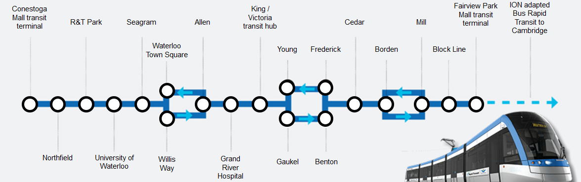
Despite LRT positioned as rapid transit with wide stop spacing, ION planners have, curiously, placed a higher stop frequency within the city cores of Waterloo and especially downtown Kitchener. Notably, they have added stops that its predecessor, 200 iXpress, does not have.


In Uptown, a new Allen stop joins the Waterloo Town Square pair. In downtown Kitchener, we have Victoria, Young/Gaukel, Frederick/Benton, and Cedar where only Victoria and the Charles St. terminal exist as stops today. And Victoria was added to the 200 only recently.

ION planners recognized the need to serve downtowns with multiple stops and to target destinations. Regional transit staff need to take a similar approach with iXpress.
  

Scaling stop spacing based on density


Density provides transit ridership through increased trip generation. Promixity to good transit service also drives ridership. Good transit service is partly driven by route speed, which is negatively affected by the number of stops along the route, so that is a major tradeoff. For most of its history, GRT has actually had too many stops on its routes, slowing down buses, raising costs and making its service less compelling.

But in attempting to deal with this problem, the region wants to treat all places the same. Stop spacing over 1km apart makes for rapid buses through our suburbia, and is an acceptable tradeoff between service quality and availability. But stop spacing at this scale within an urban core doesn't just affect downtowners, but also the potential suburban users who may head there.

We need to look at density when placing stops. We can't assume an entire downtown will be served at one central point, because there are so many potential riders who live on the edge of that dense core who transit will fail to attract, and also too many potential riders elsewhere who are destined for parts of downtown that are too far from that central point.

Every stop slows down a route, obviously. And everyone wants a bus stop on their doorstep, with a rapid trip in between. Clearly you can't add stops everywhere.

But does it make sense to treat a dense urban cluster of apartment buildings, with multiple seniors' residences and other attractions as a place with the same transit need as a suburban hinterland of single family homes on widing avenues? Can we afford to ignore the ridership potential of parts of our downtown cores presented with poor access to transit that runs right by their front doors?


Practical Outcomes


iXpress buses represent the bones of our new transit network as they link up with the ION spine. Like ION, they need to provide good cross-town service. Also like ION, they must serve the downtown cores well.

Instead of simplistic coverage goals, we need a metric that will balance overall access to transit with high quality service for the most people and destinations. 

For iXpress, that may mean switching to a 500m stop spacing standard within the boundaries of Kitchener, Waterloo, and Cambridge cores. There's so much to do in these places, so many attractions, and a large and growing number of people. In these places, transit should be compelling and convenient.

Remember, high density areas are high generators of both trip origins and destinations. Serve them well, and you'll get a lot more riders for your transit service dollar.


Avoid making the worst of a bad situation


There's an addendum here, if you're still reading this polemic.

That 204 stop at Mill? The one that turned out to be a single-direction stop with the other 300m away? This is awful. Don't do this.

Splitting stops is sometimes necessary, but always bad. Human Transit talks clearly about how split routes turn potentially useful transit into "symbolic transit", i.e. they look like good lines on a map but they don't serve anyone well. Split stops are just about as bad.

Consider the situation of St. Mary's hospital. The 204, tragically, does not serve the hospital directly (something I urged planners to consider.) But that's OK, right? There's a 204 stop 400m away at Highland. Unless you're heading the other direction, in which case it's over 700m away. You're better off taking a different bus, or a taxi.

The same goes for the hapless residents at Queen/Courtland. 350m to the "Mill" stop near the Iron Horse trail is objectively not so bad, but 650m to its companion stop at Highland is pointless: you may as well use Charles Terminal (while it's still there.)

Nobody wins with a split stop situation like this. Bad enough that it gave the impression of better coverage than was already there, an unfortunate communication gaff. It also gives the impression of useful service to a wide area, where in reality very few in the area will find the route useful. Only people who live between these two one-way stops will find them useful, and there just aren't as many of them. Certainly not as many as you'd find in around a sensible two-way stop location placed at a densely populated intersection.


Friday, November 14, 2014

Removing barriers to cycling

I've found that I've been doing a lot more late-season cycling this year than I have in the past, but only under certain conditions. What shapes my decision making is educational when it comes to understanding what makes cycling appealing to more people year-round.

The question of year-round cycling, or even full three-season cycling, is one I wonder about a lot, and written about before. Generally speaking, I don't cycle in winter. There are exceptions, including one trip to Vincenzo's on a sunny, sharply cold day (I ended up taking some paper napkins to line the holes in my helmet because I'd got the windchill equivalent of an ice cream headache.) Or the time I biked to uptown during an incredible January thaw and ended up getting my bike's brake and gear lines wet, and therefore frozen solid for the rest of the winter.

What I've learned is I have two major impediments to winter cycling-- and neither of them are temperature. The biggest single impediment is light (or lack thereof.) The second biggest is biking on snow and ice. Studded tires can go a long way to making small amounts of snow and ice tolerable, but I don't have them because once the time change sets in at the start of November, I'm no longer willing to tolerate cycling home on Lexington Road in the dark, so I haven't invested in them.

So that's where my recent increase in cycling, often in the dark, has been so interesting. It's because I've had multiple trips a week that aren't to work (as most of my cycling travels take me) but to the vicinity of U of W, either for theatre rehearsals, or for curling (at KW Granite.)

This trip is about half the length of my work commute, and often in the evening. A bike commute makes the trip about 20 minutes on my terms, whereas transit takes 30-40 minutes and with poor frequency in the late evenings or on Sunday, especially when I'm trying to get home. And if the car's available, a trip to campus has to contend with paying for parking.

I've also found that cycling to work, and then using GRT bus bike racks to get me and my steed to the UW area for evening commitments, to be a viable option.

So the bike has made a lot of sense, even as the weather gets colder and sunset gets earlier. The trip is simple, and pleasant-- side streets through the Mary-Allen neighbourhood and Uptown, then up through Waterloo Park. There are good bike racks both on campus (though theft is common there) and at the Granite (custom-built bike racks in the outline of curling rocks!) Even at 9:30pm last night, with temperatures around freezing and a chill wind, I'm finding the ride to be pleasant and comfortable.

The lesson here is that cycling conditions and trip length really affect my willingness to hop on the bike, regardless of the amount of light. A 4km bike ride through Uptown and on trails on a freezing November night is tolerable (even pleasant) but a 9km bike ride knowing I have to survive the Lexington Road expressway crossing is not. The length itself is not such a big deal, but the combination of that major barrier and the conditions of Hillside Trail are deal-breakers.

Of course, this is all quite temporary. It's November, and soon the snows will be here. Even my shorter evening trips will become untenable: the Waterloo Park trail will be a rutted, icy mess in between infrequent clearings, and can't be relied on. It will be the barrier that hangs my bike up for the winter.

Which brings us back to the same old same old when it comes to encouraging people to bike: we need  a comfortable environment to cycle in. But everyone has their own particular "deal-breakers". I will tolerate cycling on Lexington Road until it crosses a perceived-risk threshold when the after-work commute gets too dark. Others view it as a year-round deal-breaker. For trips without that kind of major barrier, some will happily jump on the bike but only while weather is warm. Others might bike year-round except for the lack of winter trail maintenance. A hardy few will tough through anything.

Each little improvement we make to the cycling network enables a few more trips for a few more people. Just looking at my usual trip corridor, the Hillside Trail paving will be one less barrier to those whose bikes (or backs, or wrists) can't handle the rough loose surface. Finally providing bike infrastructure across the expressway at Lexington would allow an entire neighbourhood to connect to the rest of the city. Examples of this kind of barrier removal opportunity can be found city-wide. They all build on each other.

And the role of transit in providing support to someone's travels by bike shouldn't be underestimated. Whether it's a flat tire, surprise inclement weather or a change in plans, a bike rack on the front of a GRT bus or within an ION light rail vehicle gives people confidence they'll be able to get through their day without a car, even if the unexpected strikes.

And this is the way we shift travel mode share. An improvement at a time, a few people at a time, and individually, as we learn what we are capable of, where, and when... without being tethered to an automobile.

Monday, November 10, 2014

The nonsensical protest around Hillside Park


Protesters against paving Hillside trails, ironically standing on a spot where they've already been paved for a decade. (photo credit: James Jackson)

I recently read about protests against plans to pave the trail surface in Hillside Park, and I am disappointed. While the residents of Ferndale Place raise a legitimate concern about how city staff notified people about upcoming work, the complaints that a few unhappy citizens are bringing forward just don't make sense. 

One complaint is that upgrading the trail surface will ruin this park as a natural gem. As a daily user of the park, I can attest that the park is a beautiful natural oasis, but less than two years ago it was a muddy construction zone filled with heavy earth moving equipment. If the park can survive a sewer replacement, it can withstand a paved trail.

Sewer reconstruction in Hillside Park: where were protesters then?

Furthermore, worries about "environmental damage" completely ignore the current reality. I saw gravel trails washed out by stormwater three times in 2014 alone, and countless times before. After each incident, heavy vehicles truck in tons of new stone and sand to repair dangerous washouts that are sometimes a foot deep. With each new storm, this material is spread into meadows and silts up the creek. A hard trail surface will permanently solve this problem and prevent injuries.

Storm runoff gouged this gravel trail down to the foundation layer in 2014.

What is lost in these protesters' message is how Hillside Park's degraded, loose gravel trails make it inaccessible to many in our community. Paving the trails will improve accessibility for all: in wheelchair or mobility scooter, with stroller, as well as on bike or on foot. Virtually every other city park provides paved trails without diminishing the natural environment, including Forwell Creek Park which directly connects to Hillside, so that they are not a barrier to those of us who struggle with mobility challenges.

The concerns of a few residents who don't want any changes need to be weighed against the needs of everyone. Accessibility must trump aesthetics. Hillside Park is a public space, not a private backyard.

Sunday, October 26, 2014

Election thoughts, LRT thoughts

I haven't posted here in a long while, because as the election got rolling, most of my energy went towards TriTAG, who I have been working with since 2012. Once again, we have a big LRT fight.

In the last few months, we've seen the rise of a well-funded anti-LRT crusade led by Jay Aissa. And as a result, it's the same old battles, the same old wounds reopened, and a lot more vitriol and no small amount of misinformation and unfounded arguments.

TriTAG's efforts this election were meant to be focused on the 2014 Election Candidate Survey, which has been very successful so far. That was back in the optimistic early days when we thought the election might be about tackling new issues. As time went on, it became clear that we needed to "mythbust the election" to deal directly with some of the myths being peddled by the crusaders.

On the eve of the election, I thought I would say a few words about why I got engaged with the LRT issue years ago, and why it continues to be the most important battle to win.

In 2011, we faced a choice between two very different solutions for "higher order transit". One was bus-based, and the other was rail-based. Despite the fact that LRT is more expensive, it appears to achieve its goals better: namely, shifting more people to public transit and also shifting development to focus on intensifying the core. It also provides better long term value by providing the capacity we'll need in a couple of decades.

I agreed that LRT was the better option, and that formed a large basis for my support. I also knew that to be successful, LRT alone isn't enough, but we need an entirely redesigned transit network supporting it. The fact that ION is not meant to stand alone and knowing what the central corridor would need to properly support a better bus network also made me favour it. But I also knew something else: that Light Rail would become a symbol for Waterloo Region. A symbol whose importance should not be dismissed.

We have a big problem in North America. We just don't really believe in transit. The car is king, and we can't really even conceive of how that will ever change. But time moves quickly, and as we've spent the last 60 years sprawling our cities ever outward, we need to spend the next 60 reshaping them to be viable, livable places.

Much more so than a rapid busway, light rail is a visible sign that we can alter a city's trajectory. It will be on almost every stock photo for the region, for UW, for Uptown and Downtown. It will quickly become an indelible part of our identity, and we will not tolerate anything less than success for it. Which means that LRT will open up the region to ongoing transit improvements. It will shift the attitudes of the entire population. That shift in mindset will also translate into ridership.

Whereas-- and here's the kicker-- it's unlikely that Bus Rapid Transit would be allowed to succeed.

Had we chosen BRT in 2011, I would be supporting it today. But it would face an uphill battle. The problem with BRT is its flexibility: a busway is a busway, sure... but too often, BRT systems are often watered down during the design phase. I have no doubt we'd face pressure here to cut the dedicated busway where it would be needed most. It's possible that the very definition of BRT, as a rapid bus operating on its own right of way, might even be rewritten by politicians unwilling to displace cars at all.

LRT, on the other hand, is much harder to erode. It stands a better chance of surviving to deliver on its promise.

I doubt that many of the anti-LRT crusaders are anything but just anti-transit. They'll tolerate what's there now, but if they can kill LRT while talking up BRT as "a much better option", I have no confidence they'll deliver anything like "gold standard" Bus Rapid Transit.

Helping Waterloo Region make a shift towards better mass transit is why I've been fighting so hard. We're really the first city in Ontario rolling out what transit expert Vukan Vuchic (see his Waterloo speech here) calls "medium capacity transit". LRT can bridge the gap (in terms of capacity, speed, and cost) between buses and subways, and there are half a dozen cities in Ontario that could benefit from it. But Toronto, which needs to get on building multiple LRT lines as the only affordable way to address its transit woes, has really poisoned the discussion with "Subways, subways, subways" and muddying the difference between LRT and mixed-traffic streetcars.

So it's on us. We can show the cities like London and Hamilton and Mississauga and Scarborough just how LRT can work. We can give form and value to something that some just can't imagine until they see it in action.

But first we have to finish building it.

Please vote on Monday. Vote for leaders who will make LRT a reality. A lot is riding on this train.