Monday, May 30, 2016

Strava and a curious tale of WW2 bombers

The city of Waterloo published an apparently innocent tweet that stopped me in my tracks.


Now, this is a really interesting move on Waterloo's part, but it left me feeling concerned. I'd like to talk about why, in the hopes that it helps Waterloo and other places avoid falling into a common trap.

First, though, credit where credit is due: the city of Waterloo has been doing some excellent stuff over the last few years, by connecting and improving its trails, continuing to extend bike lanes, and supporting a new uptown streetscape with protected bike infrastructure (which will be joined by more trails along Caroline and Erb as part of a regional reconstruction). There are signs of progress in finally making the Lexington overpass bike-friendly. It's really encouraging and I'd like to see other cities (like Kitchener) take a closer look at their initiatives.

Also positive: Waterloo has also taken an interest in data. Loop counters are now installed on several trails across town, counting travelers on foot and on bike year round. Waterloo wants feedback on its improvements, and wants to let real data help them drive decisions. Maybe they can also show that data live at some point!

Now, it seems Waterloo has taken up with Strava to use Strava's health and fitness tracking data to show where people are jogging and biking, using their Metro planning service, which looks like an attempt by Strava to monetize their user's data. (Update: I've been informed that Waterloo isn't using Metro, just looking at the publicly available information on Strava.)

If this is the case, Waterloo had best tread very carefully and realize what they are getting, and what they are not.

There's no arguing Strava's cycling heat map is a beautiful thing. Who doesn't like seeing where Strava users are biking? How couldn't this help us make decisions on cycling infrastructure?

It's so beautiful.
Have you spotted the problem yet? You should ask who are Strava's users, and what are they doing. Are they actually representative of the people you're trying to encourage to use a bicycle?

A cautionary tale


Here's a lesson from history as to why knowing where your data comes from is so important.

During World War II, Allied bombers would fly out over Europe to bomb targets and sometimes they would be shot down. The odds of crews surviving the many missions of their "tour" was depressingly low, because mission after mission, the chance of being the victim of guns or flak catches up with many.

In an effort to increase the survivability of their bombers, military leaders and engineers decided they needed to add armour to their bombers. They couldn't add much-- armour is heavy, and bombers need to fly. So, where would it help the most?

They came up with a clever idea: look at all of the surviving bombers and where they were shot up. Where they were being hit most, it was argued, was where the aircraft should be strengthened.

Statistician Abraham Wald turned this argument on its head. You're only looking at the bombers that came back, he said. They don't need more armour where they've been hit. They need armour where they haven't been hit. It turns out this was around the pilots and in the tail.

All the bombers that had been hit around the pilots and in the tail hadn't returned, so nobody had good data on them. But bringing those bombers and their crew home was the goal. And until Wald pointed this out, nobody realized the mistake they were making.

The black areas mark hits on the surviving bombers


This is called Survivorship Bias and it happens all over the place.

Survivorship Bias and Self-selection Bias


It's not the only kind of statistical bias that Waterloo needs to worry about here, but it's a big one. People who don't bike but could, don't use Strava. The only people Strava can collect data on are those who have managed to make themselves able to tolerate riding on our streets and roads. Everyone who can't has been filtered out.

There's more.

Strava calls itself a "social network for athletes". Its cycling userbase has a lot of athletic cyclists who use Strava to compare their performance to others. In other words, Strava's data is heavily weighted towards the enthusiastic, confident and athletic cyclists who look for places they can ride fast for long distances, and who are more willing to ride in traffic.

This presents a second source of bias: People choose whether to use Strava. This is Self-selection Bias. The people who ride bikes, who choose to use Strava, may not relfect all people riding in general.

(Look ma, I'm finally putting my math degree to good use!)

So what does this mean for Waterloo, which like many cities, wants to grow cycling? The question here is, are the people who they want to attract to cycling similar to Strava users? Do these users' choices about where to ride reflect where the hypothetical 60% Interested But Concerned want to ride, or the trips they'd make?

I would say there are very significant differences between these groups. Strava's cyclists are the "survivors" of bicycle-unfriendly city design, that keeps all but the bravest of us off our bikes. They are making very different choices about their cycling than the majority of people who say they would like to ride a bike but don't. The first such choice is that these cyclists are already riding on streets and roads that would make most of us very nervous.

This is not to say the data is useless. Some of it reflects overall truths: the great success that is the Iron Horse Trail, for instance. But let's take a closer look at these maps. They can lead you into some strange interpretations that don't make sense.

1. Students on bikes are missing

University of Waterloo

Around UW, there is heavy bike traffic on the Laurel trail, and on Ring Road, and on University, Columbia and Westmount. There are virtually no traces within Ring Road.

This is highly surprising. The interior UW campus has many bike racks littered with bikes. Why aren't paths to these points showing? Could it be that students on bikes aren't using Strava? If so, what does that say about how Strava data represent their travel patterns off UW campus?


This is a sign that Strava is completely silent on a major bike-using demographic. Yikes.


2. It takes a lot of nerve to cross 85 on University Avenue

 
University between Weber & Bridge


According to Strava, there's little difference in cycling on University Ave. where bike lanes exist (west of Lincoln Road) and where they don't (over the expressway). In fact, it looks like there's plenty of people on bikes going crossing the expressway on University Avenue. My own experience has been that anyone with a choice avoids crossing here, unless they are supremely confident about mixing with high speed traffic merging on and off the highway.

Someone might look at this and interpret it as a case where bike lanes aren't really having an effect, and that usage by people on bikes is just fine on University Ave. For a certain kind of athlete, that is completely true. When considering the general public, that would be a mistake.

3. Where are the neighbourhood riders?

Eastbridge neighbourhood


If you look at this map, you'd be led to believe that virtually everyone is biking on arterial roads. My experience is that there are a lot of casual riders on neighbourhood streets within this area, and younger students who traverse the quieter streets. These are clearly not being captured in Strava's data set.

What's more, this image doesn't really capture who wants to ride, but can't. The southeast portion of the image is Conestoga Mall, with a supermarket and a transit terminal. Do the lack of traces to here mean that nobody bikes to Conestoga mall? Or just that people who use Strava aren't going shopping or connecting to transit? We can't know. Nor can we determine if the neighbourhood would appreciate a little more bike accessibility at the mall.

The map says nothing.

Approach with Caution


These are just a few examples of where Strava as a planning tool comes up short. As I said before, the data is not without value, but if your goal is to make cycling attractive to the majority of people, then at best this information is incomplete, and at worst it can be deceptive. And it won't always be obvious when that happens, either.

What Strava shows is where a very particular kind of cyclist rides. It doesn't show where improvements would do the most good for the people who could ride but choose not to, which is where cycling growth will come from. Strava wants to make money with their data, so I don't trust them to be forthcoming about this, nor would I say that their agenda matches those of the cities hiring them.

The city of Waterloo should be commended for seeking out data to base their decisions on. I trust the they know that Strava is just one tool among many in their toolbox. It can help them visualize how the city looks from two wheels, but they still need to take a step back from these maps and analyze Waterloo's bike network with careful thought and direct observation.

Let's not lose sight of that.

Meanwhile, I guess I should install Strava. If nothing else, I want my own trips to be represented!

Wednesday, May 25, 2016

A tale of fickle, elusive Transit

Update 27/5: Good news! GRT is reinstating the Weber/Guelph stop to serve the midtown area and it will be back up by mid-next week. The Weber/Union stop will remain closed, as it sees additional service from route 8, and was less used than Weber/Guelph. It was also only about 500m away.

There is concern about keeping the 200 on schedule, but it's encouraging to see responsiveness from GRT on this! I guess there was more than one crotchety blogger on the phone with them after all. For those of you who provided feedback about how you were affected, thank you.

Maybe I need to change the ending to this fairy tale...


nce upon a time, there was a happy central neighbourhood called Mount Hope. In Mount Hope, being very central (directly between two great cities), Transit was present and available, as you might expect. Some residents in the neighbourhood chose to live there because of this, as they could travel the great Central Corridor through the Cities without needing a Car. 
 
But one day, the Great Road Eating Rail Monster came, and Transit ran far away. And the people of Mount Hope were sad.

A little later, just as sad people in Mount Hope were trying to figure out how to live without Transit (likely by buying Cars to drive the few roads not being eaten), Transit came back again! In a different place, but still reachable to the residents of Mount Hope, and they breathed a great sigh of relief.

Unfortunately, it was not to be for long. One day just a few months later, Transit went away again. The Central Corridor buses were to drive by, with strict orders to not stop for the poor people of Mount Hope. In its place, a different bus would come every now and then, once in a while on Saturdays and never at all on Sundays, and it would take people where it went, which was usually not where they wanted to go. And it would take people when it showed up, which was often not when people needed it, because it only came every now and then, only once in a while on Saturdays and never-- it was decreed, never! on Sundays. This was called "Transit", but the people of Mount Hope were not fooled.

But they were once again sad-- not to mention, confused-- and they started browsing new car ads on the Internet because who can trust Transit that comes and goes? The Great Road Eating Rail Monster would eventually leave, having birthed a beautiful Train. But that Train would see fewer riders, because the people of Mount Hope were all driving the Cars they had to buy to get around while the Monster raged and Transit had proven too fickle and elusive to rely on.


The End.


... OK, so, not a great fairy tale. Let me explain. Once, Mount Hope had good access to transit, as the fairy tell told.


And then:
  • The 4, marginally useful at the best of times, was rerouted to cover the cancelled 18.
  • When the 200 iXpress detoured over to Weber because of ION construction, it didn't stop anywhere in between uptown and downtown, leaving a lot of riders in the lurch. 
  • Simultaneously, route 7 shifted over to Park St., which was great for the Belmont neighbourhood.
  • Simultaneously, the low-frequency route 6 turned off Wellington at Weber.
  • The Mount Hope neighbourhood has been left high and dry, with only the very occasional route 4, which is a milk run bus with limited service (and no Sunday service.)

But then, the 4 needed to be detoured as well! So to infill the 4 on Weber, GRT added stops for 200 iXpress (which runs every 10-15 minutes and has good Saturday and Sunday service) at Weber/Union and Weber/Guelph.

This gave back good transit access to the Mount Hope neighbourhood.

Now that the 4 is returned to its normal route, the 200 no longer stops at these locations. This is despite the fact it drives right by them, every 10-15 minutes.

The result is awful:


In fact, 200 iXpress travels for an astounding 3.5 km without stopping even once. From the north end of Uptown, all the way to King/Victoria. Certainly, Mount Hope isn't the only area affected by this-- Mary/Allen is, as is anyone in the Midtown area relying on the 200 to get them to points south of Fairview.

But with all these changes put together, the Mount Hope neighbourhood is once again left like an island without transit, unless you count the occasional lonely route 4 bus. And very few people will count this for anything. Frequency matters, and routing matters. GRT has ignored these things when deciding the 200's detour.

In 2015, GRT saw transit ridership fall for the second year in a row. Even accounting for changes to school student busing, and even with new service being added, GRT ridership still fell.

The problem with Mount Hope is just part of a larger issue affecting ridership, and that is the chaos and disruption of ION construction. But unlike a lot of the other aspects of this problem, this one can be solved easily and locally. In fact, the solution was already in place. All we have to do is return to it.


All we have to do is reintroduce stops at Weber/Guelph and Weber/Union for 200 iXpress.

GRT, are you listening?


Thursday, October 29, 2015

Bikelash arrives in Waterloo Region


There’s a scourge on our roads, folks. Our comfort and safety is being threatened by road users who bend and break the rules, who fail in their duty of care, and who often move in casual disregard for their own safety or that of others.

Cyclists!

Oh, and drivers! And also, pedestrians!

Actually, all of us human beings, regardless of whether we're -ists or -ers or -ians.

Despite decades of regulation and good intentions, it doesn’t matter whether we’re behind the wheel, behind the handlebars or just simply on foot: we still get it wrong. People speed. People jaywalk. People ride on the sidewalk. And sometimes, people commit mistakes of judgement that have tragic, fatal consequences.

But lately, the Record’s columnists have taken it upon themselves to single out one group of road users for special attention: those darned cyclists. In doing so, they’re reinforcing the myth that we’re all in our own warring camps: the drivers against the cyclists against the pedestrians. Never shall they mix!

This myth ignores the reality that the “cyclist” you pass in your car is just a person on a bike, today. Tomorrow, they may be driving down your street as you walk to the bus. You would hope that when they do, they obey the speed limit. Today, they are hoping you give them at least one metre and pass carefully.

Maybe we should stop saying "cyclist" or "driver" or "pedestrian" and start talking about people getting around in different ways.

You may have heard about a bylaw review where the region is trying to sort out some of the rules that leave us tied up when we try and get around. It will rationalize rules about the use of rollerblades on trails and how automobiles and light rail will interact, for instance. The region also has a bylaw prohibiting side-by-side cycling which is redundant in the face of the Highway Traffic Act, which has clear rules that slower traffic should turn out to the right to allow passing. Cities like Toronto and Ottawa have long since removed such a rule from the book without problems. (Toronto has a great guide on when you should, and shouldn't, consider riding beside someone else.) Region staff proposes tidying this up as well.

But, it's that one proposed rule change has provoked quite a reaction. If ever there was a tempest in a teacup, this is it.

Record columnist Luisa D’Amato decries this and paints “cyclists” as overprivileged one-percenters who are “wagging the dog”. Peter Shawn Taylor has reached all the way around the world to an Australian study years ago that opined side-by-side cycling might create some kind of aggressive cyclist menace, like some kind of “Reefer Madness” awaits us if we don’t keep our society’s bike users in check.

It’s been a the week since that column was published. Every week, 40 people die on the road in Canada alone, the vast majority because of cars. The idea of bikes stealing away the road and threatening us all whips us into a lather. But dozens of real deaths every week get a shrug and a pass. Accidents happen.

For all I talk about riding a bike, I don't see myself as a "cyclist". Like many others, I ride my bike on our region’s roads. I also drive my car on those same roads. The difference is that when I ride, some people have already judged me with all the sins and offences of every bad cyclist they have seen, and they have found me guilty. If I'm behind the wheel, I carry no such burden.

And yet it’s behind the wheel that we, as human beings, are the most dangerous.

These latest developments are part of a new wave of bikelash in Waterloo region. (Some would say that's a good sign.) After Kitchener traffic calming projects brought bike lanes to a couple of streets in the face of street residents' objections, there's a sense that we're somehow doing too much for "those people". But there are no "those people" involved. There's just all of us, trying to get around.

And if more of us are able to get around by bike, is that really so bad? We're much, much less likely to accidentally kill someone on the way.

Wednesday, June 3, 2015

Cycle path for Lexington overpass?

Wednesday night, Waterloo city staff presented their proposal for Lexington Road to the public. After three years of silence, we now get to see how we might bridge Waterloo's great cycling gulf.

The Basics 


The proposal is an interim plan. Staff are telling us what they can do now, instead of ten years from now.

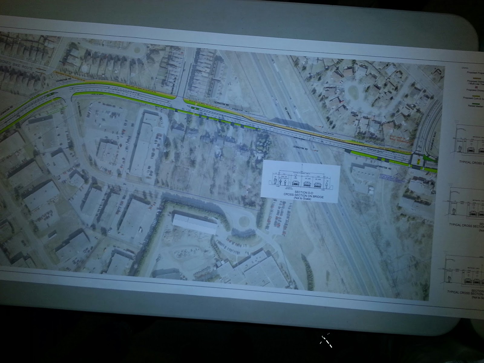
As part of resurfacing Lexington Road, the city of Waterloo proposes to create a multi-use trail that turns into a 2-way cycle path over the highway 85 overpass. Because the overpass cannot be structurally modified, the idea is that this cycle path would take up a traffic lane and be protected from traffic by some form of barrier, possibly jersey barriers.

The proposed multi-use trail will connect Davenport to Holbeach Crescent. That will get people on bike across the expressway, and provide connection through the neighbourhood to the Forwell trails and the rest of the Waterloop.

Click to embiggify.


This part of the Lexington corridor would turn into 2 eastbound lanes, and 1 westbound lane. Travelling further west, it opens up to 2 lanes by the time you reach the Dearborn traffic lights at the bottom of the hill. Further west, there are not many changes.


Not to be forgotten are a couple of pedestrian refuges which will make crossing Lexington on foot safer, and catching GRT's route 31 bus on the other side of the street less of a terrifying adventure. (Seriously, I've watched the terrifying game of Frogger that these riders play.)

So, why this plan? What's going on?

The Background


Like I said, this is an interim plan. In ten to fifteen years, this road could be reconstructed. Before then, the city hopes to have acquired the land they need (especially around Weber) to create a permanent cycling solution while not constricting traffic. That's their goal.

The bridge has been, and continues to be the worst problem. Anything the city does to it has to be approved by the MTO. Structural changes are extremely unlikely. Even what's proposed here still needs their blessing. The good news is that the MTO is apparently much more willing to consider this kind of plan now than they were four years ago.

The last time this stretch of road came up, a proposal to reduce lanes to introduce on-street bike lanes further west was rejected and deferred by council. Possibly as a result of that, staff want to maintain 4 road lanes west of Dearborn leading up to Weber.

What staff have presented fits within their budget. This means they don't need extra money to do this. But is it enough?


The verdict


What this proposal does is add a vital, safe cycling link across the expressway to connect Eastbridge to the Waterloop. Filling that gap is critical. So that's very good.

It doesn't complete the Columbia/Lexington east-west corridor. That is a disappointment.

Despite that, I believe we must support this proposal. Here's why:

To "do this right" would require the city to fund a new multi-million dollar plan that will take years, maybe a decade. Recognizing that, City staff rescued the idea of an interim plan from the scrapheap.

They've come up with something that solves the issues that council raised with the previous proposal. They've done it cheaply, and they could have this in front of council for approval this fall, with potential construction in 2016. We need more of this imaginative problem solving. There are so many critical gaps and problem spots in Waterloo region's cycling network that need attention now. But there is only so much money to go around.

If you punish staff for coming up with pragmatic solutions that can be implemented quickly, we will only see improvements when roads come up for full reconstruction, which means our network will only get random improvements going in haphazardly over the coming decades without regard to need.

What this proposal does well is connect Eastbridge to the rest of Waterloo in a way that people of all ages can hop on a bike and use. That is the critical need. It also helps us build cycling numbers and that will in turn increase momentum for other incremental improvements.

And it is a template for future problem-solving. Not every improvement needs to be as polished and completely conceived as Uptown's streetscape. What we need are pilot programs. We need staff and councils willing to engage in low-cost risk taking. We need to fill the gaps in our cycling network now, whatever way we can.

That's why this proposal deserves a thumbs up. It's not the big win some people were hoping for, but it is definitely a win. And small wins over time add up to big gains.


Tuesday, June 2, 2015

Columbia/Lexington road improvements consultation Wednesday!

This is a big one! After a four year wait from the last attempt at addressing Waterloo's great cycling gulf, Lexington Road over the expressway is finally back on the table.


There is a public consultation for Columbia St. E and Lexington (from King to Davenport) Wednesday, June 3rd from 6:00pm to 8:00pm, at the Mennonite Brethren Church, 245 Lexington Road.


If you want to ride a bike in the city of Waterloo, please consider attending. If you can't, then make a point to provide feedback when the material from the consultation goes online.

Let's recap:

  • The city of Waterloo currently has no bike infrastructure that crosses the expressway. It is Waterloo's great cycling gulf.
    • Soon, there will be a multi-use trail underneath the expressway at King St. North, which will provide some access to the Conestoga mall area.
  • Lexington Road is the only crossing in Waterloo without on/off ramps.
  • Lexington Road is the only crossing in Waterloo that is a city street (not a regional road).
  • Lexington Road is the quietest, lowest-traffic crossing point in Waterloo. It also appears to be the busiest cycling crossing point of the expressway.
  • Lexington/Columbia is an as-yet incomplete planned east-west cycling corridor. This study area is the critical missing piece.

In 2011, the city consulted on potential improvements that included on-street bike lanes, and reducing Lexington to 3 lanes between Davenport and Marsland. Despite the fact that the road is overbuilt for the amount of traffic it sees, the proposal drew concerns and unanswered questions from council at the time and the project was deferred in 2012.

Since then, Davenport's road diet has been completed, and so have the bike lanes along Lexington east of Davenport (with some multi-use trail action coming as well.) Hillside Park and Forwell Creek Park are now part of the "Waterloop" and crossing and connectivity points are being improved.

What will staff bring forward at the new consultation? I'm not sure, but it will hopefully provide a good cycling connection to the Waterloop, and reduce the speeding problem along Lexington. Could it even fill the very challenging King-Weber gap? We'll see.

It will need public support! I hope to see you there.

Thursday, May 28, 2015

Uptown Streetscape is a thing!

On Monday, I had the great pleasure of speaking to Waterloo City Council on behalf of the region's Active Transportation Advisory Committee. In our last meeting, the committee endorsed the plan presented by the project consultants and city staff to revamp Uptown Waterloo's streetscape with wider sidewalks and protected bike lanes.

I also had the pleasure of watching that plan passed unanimously.

The plan was the product of multiple consultations and strong public feedback, which I wrote about previously here and here. I also helped get the word out about protected bike lanes on twitter, on CBC radio (sadly the clip is no longer available), and in blogs. Together with the efforts of a number of passionate individuals, including the inimitable Graham Roe (whose petition garnered a thousand signatures) and tireless Mike Boos (who designed the amazing infographic) we got Waterloo informed, and engaged.

The people spoke, and the project team listened. The BIA got on board, and so did the politicians. What a journey! Considering that in 2010 I heard from one streetscape committee member about the very passionate arguments around the table about removing any traffic lanes at all, this points to a real evolution in thinking by many members of our community.

There are still a few rough edges. While Waterloo has a plan to replace lost parking (the streetscape plan will cost 22 parking spaces, but the LRT construction will affect considerably more), this plan still needs to become a reality and businesses will need to see their customers continue to reach them, whether it's by foot, bike, or car.

There is also the question of intersection design. Protected bike lanes will interact with these intersections similarly to on-street bike lanes, in that they'll be alongside traffic lanes and clearly visible at intersection approaches.

But there are other approaches we could take, including this adaptation of Dutch intersection design for Boston's Commonwealth Avenue.


Or even better, we could take a step further and implement a "protected intersection".


Just some thoughts on how to polish this plan to perfection.

Wednesday, May 27, 2015

The art and science of transit stop placement

Man, it's been a while since my last post! I've been busy with the Active Transportation Advisory Committee, still working a little with TriTAG, but mostly taking care of real life. But the march of progress brings new lessons and observations. I have a few things to post about now, but I'll start with what is freshest on my mind.

And that is: we're seeing new transit routes being created, and we're making some mistakes with transit stop spacing and placement. But there's confusion about why they're mistakes. Mistakes are being made because we're treating the entire region with the same standard, without considering that parts of our region, the cores, have more potential riders and potential destinations.  

Our system will benefit more from more closely spaced stops at strategic locations within these dense urban areas than from assuming one central stop can serve an entire core, or that one standard can serve an entire region.

Some background:


The new 204, and Queen St.


Regional Council's Planning & Works committee heard from a few delegations on Tuesday about the upcoming GRT improvements. There are concerns about rationalizing existing routes with the introduction of a new iXpress route. But there was also a vocal debate about that new 204 iXpress (travelling along Highland to Queen, through downtown, and out east along Victoria.) In particular, about its stop placement.


 A couple of residents of the Bread and Roses coop at Queen and Courtland took issue with the (apparent) stop placement at Queen and Mill, instead of what looked more logical to them, Queen and Courtland, where there are almost a thousand housing units just in the nearby major buildings alone.

In fact, it got even messier when it was revealed that the "GRT stops" at Queen/Highland and Queen/Mill were actually both 1-way stops, separated by a few hundred metres, a situation which serves nobody well.

In response, staff and some councillors argued that this area is well served by other routes and by the planned stop at Charles St. terminal. But that misses the point that the 204's potential is being undermined.

First, let's talk about GRT's defined goals.


Stop coverage


GRT stops are defined to have a 450m effective radius, for calculating what parts of the city are covered by transit. ION LRT stops will have a larger effective radius, on the logic that people will walk further for better service. GRT's "iXpress" stops are also intended to have a larger spacing than regular routes, so that the buses can move faster.

These standards are important because they give GRT and the region an objective measure they can use for planning, and some defense against the reality that quality of service is uneven, and changes will always make some people unhappy. GRT works very hard to make sure routes and stop placements are sensible. Coverage standard is not the only tool in their toolbox, but it's a big one.

The problem is, it's only a tool, and it won't maximize the benefit or performance of transit. And being bombarded by people complaining about the removal, the moving, or even the placement of a route or a stop, planners are still missing important information amongst the noise.

The 204 stop placement issue reveals this. An objectively strong argument is made for putting the stop here rather than there. Region staff and councillors seem ready to dig their heels in against this argument.

What do they need to consider?


Trip Generation?


Transit stop placement needs to consider the potential for trip generation. And this analysis is already being done. In the example above, there is clear potential for trip generation at Queen/Courtland, but the location is being discarded because it fails other tests: coverage overlap with the terminal, for one. Route overlap too, which is really coverage again because the coverage question isn't where do you want to go, but can you get to anywhere at all.

Our downtown cores are big trip generators. Transit is most attractive when it stops close to a potential rider or their destination. Adding stops closer together within a downtown makes transit more attractive to a lot of people.


Modal Shift?


A delegate made a strong point about the many current car users who live in the immediate vicinity of Queen and Courtland, and how strong transit presence and convenient stop placement in that location will have a big bottom-line effect on the region's efforts to increase the modal share of travel by transit.

This point is so far unaddressed by Region staff, who largely see the location as sufficiently well served by transit without assessing the quality of that transit versus the trip generation potential of that location.

Again, to satisfy the coverage goal, it doesn't matter where you can get to, or how frequently, as long as a bus going anywhere shows up nearby at some point. This is the reality for much of the region's suburban areas which are hard to serve with transit. It is a poor defense for a major urban node.

If the region can provide quality, frequent, convenient iXpress transit service to a large number of current drivers and potential riders, the potential for ridership increase may outweigh the incremental impact of an additional stop.


Travel within downtown?


The potential for transit use within a downtown core, in particular Kitchener's quite substantial downtown, is being completely missed in this discussion. By assuming all transit users will gravitate to a central terminal, GRT is actually making it extremely difficult to cross from one end of our downtown core to the other.

The effect of this is actually turning downtown edges into transit deserts. There's so much service at the terminal that routes, especially iXpresses, don't need to stop nearby. Except that those living on the outer edge of a dense downtown are presented with a long walk, despite the fact there is much more potential for transit use there than along most of the rest of the route.

And if you want to get to the other side of downtown, you're out of luck. You could walk to the terminal, assuming you can find a bus that will stop near where you're going. Or you could try a local route that does stop frequently enough, but then pay a layover time penalty at the terminal. Or you could play transfer roulette.

If the region wants to make more of our downtowns accessible by transit users, it needs to stop assuming "one big central point" is all a downtown needs.


What about ION?


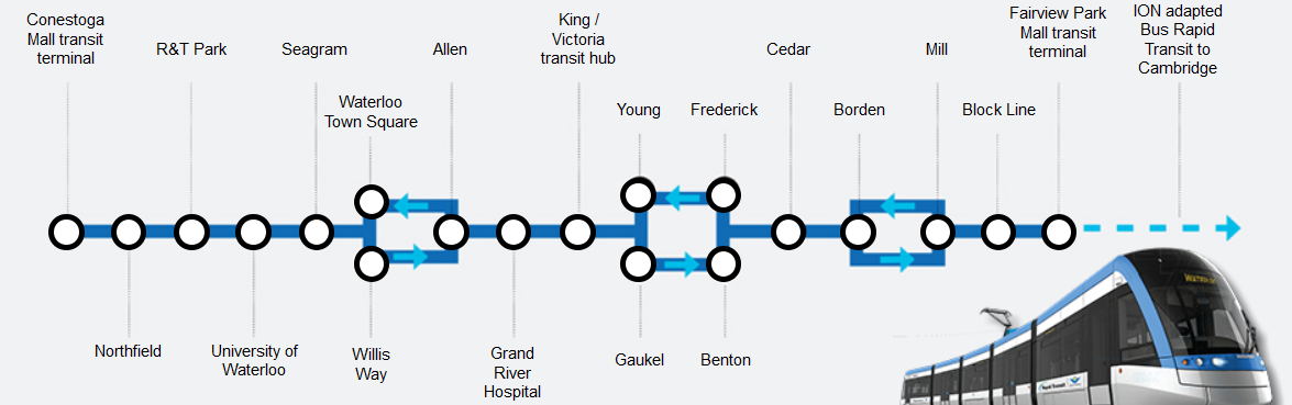
Despite LRT positioned as rapid transit with wide stop spacing, ION planners have, curiously, placed a higher stop frequency within the city cores of Waterloo and especially downtown Kitchener. Notably, they have added stops that its predecessor, 200 iXpress, does not have.


In Uptown, a new Allen stop joins the Waterloo Town Square pair. In downtown Kitchener, we have Victoria, Young/Gaukel, Frederick/Benton, and Cedar where only Victoria and the Charles St. terminal exist as stops today. And Victoria was added to the 200 only recently.

ION planners recognized the need to serve downtowns with multiple stops and to target destinations. Regional transit staff need to take a similar approach with iXpress.
  

Scaling stop spacing based on density


Density provides transit ridership through increased trip generation. Promixity to good transit service also drives ridership. Good transit service is partly driven by route speed, which is negatively affected by the number of stops along the route, so that is a major tradeoff. For most of its history, GRT has actually had too many stops on its routes, slowing down buses, raising costs and making its service less compelling.

But in attempting to deal with this problem, the region wants to treat all places the same. Stop spacing over 1km apart makes for rapid buses through our suburbia, and is an acceptable tradeoff between service quality and availability. But stop spacing at this scale within an urban core doesn't just affect downtowners, but also the potential suburban users who may head there.

We need to look at density when placing stops. We can't assume an entire downtown will be served at one central point, because there are so many potential riders who live on the edge of that dense core who transit will fail to attract, and also too many potential riders elsewhere who are destined for parts of downtown that are too far from that central point.

Every stop slows down a route, obviously. And everyone wants a bus stop on their doorstep, with a rapid trip in between. Clearly you can't add stops everywhere.

But does it make sense to treat a dense urban cluster of apartment buildings, with multiple seniors' residences and other attractions as a place with the same transit need as a suburban hinterland of single family homes on widing avenues? Can we afford to ignore the ridership potential of parts of our downtown cores presented with poor access to transit that runs right by their front doors?


Practical Outcomes


iXpress buses represent the bones of our new transit network as they link up with the ION spine. Like ION, they need to provide good cross-town service. Also like ION, they must serve the downtown cores well.

Instead of simplistic coverage goals, we need a metric that will balance overall access to transit with high quality service for the most people and destinations. 

For iXpress, that may mean switching to a 500m stop spacing standard within the boundaries of Kitchener, Waterloo, and Cambridge cores. There's so much to do in these places, so many attractions, and a large and growing number of people. In these places, transit should be compelling and convenient.

Remember, high density areas are high generators of both trip origins and destinations. Serve them well, and you'll get a lot more riders for your transit service dollar.


Avoid making the worst of a bad situation


There's an addendum here, if you're still reading this polemic.

That 204 stop at Mill? The one that turned out to be a single-direction stop with the other 300m away? This is awful. Don't do this.

Splitting stops is sometimes necessary, but always bad. Human Transit talks clearly about how split routes turn potentially useful transit into "symbolic transit", i.e. they look like good lines on a map but they don't serve anyone well. Split stops are just about as bad.

Consider the situation of St. Mary's hospital. The 204, tragically, does not serve the hospital directly (something I urged planners to consider.) But that's OK, right? There's a 204 stop 400m away at Highland. Unless you're heading the other direction, in which case it's over 700m away. You're better off taking a different bus, or a taxi.

The same goes for the hapless residents at Queen/Courtland. 350m to the "Mill" stop near the Iron Horse trail is objectively not so bad, but 650m to its companion stop at Highland is pointless: you may as well use Charles Terminal (while it's still there.)

Nobody wins with a split stop situation like this. Bad enough that it gave the impression of better coverage than was already there, an unfortunate communication gaff. It also gives the impression of useful service to a wide area, where in reality very few in the area will find the route useful. Only people who live between these two one-way stops will find them useful, and there just aren't as many of them. Certainly not as many as you'd find in around a sensible two-way stop location placed at a densely populated intersection.